Beijing Yongdingmen Park: Visitor Guide to the Remains of the Southern Section of the Central Axis (Updated for 2026)
The remains of the southern section of the Central Axis are not a palace, sacrificial altar, temple, or city gate. They are a stretch of road that was buried underground and later unearthed by archaeologists—a path once traveled by emperors.
In 2024, it was inscribed on the UNESCO World Heritage List as a core heritage element of Beijing’s Central Axis. Admission is free, no reservation is required, and it is directly accessible via Subway Line 8.
Please note, however, that this is not a traditional enclosed scenic area, but rather an open-access road remnant scattered across various locations along the southern section of the Central Axis.
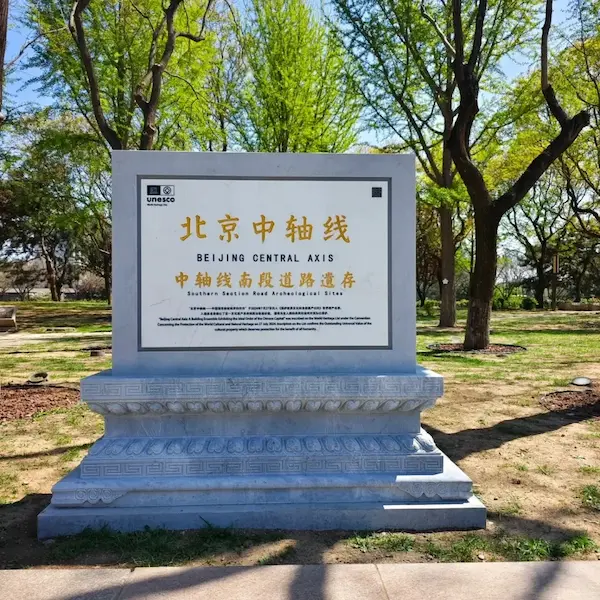
Table of Contents
Practical Information (Must-Read Before You Go)
| Item | Details |
| Name | Southern Section Road Archaeological Sites (English: `Southern Section Road Archaeological Sites`) |
| Location | Dongcheng District, Beijing; the southern section of the Central Axis between Yongdingmen and Zhengyangmen, with a total length of approximately 3,000 meters |
| Subway (Recommended) | Line 8, Yongdingmenwai Station (`Yongdingmenwai Station`); walk north for about 10 minutes after exiting the station. For information on how to use transit cards, ride the subway, and make electronic payments in Beijing, please refer to my [2026 Step-by-Step Guide to Beijing Subway and Transit Payments] |
| Bus | Routes 2, 7, 17, 20, 36, 71, etc.; get off at the “Yongdingmennei” stop |
| Driving | Not recommended. Parking is difficult around Yongdingmen |
| Admission | Completely free; no reservation required |
| Hours | The park is open all day, every day of the year |
| Best Times to Visit | Early morning from 6:30–8:00, when crowds are at their lightest, and the sunlight casts a slanting glow on the stone slabs of the Imperial Processional Way; or after 3:00 p.m., when the sunlight bathes the edges of the stone slabs in a pale golden hue |
| Recommended Duration | 30 minutes–1 hour |
| Dress Code | Wear comfortable flat shoes. The ruins are located within the park’s green space, and the ground is level |
| Budget Guide | 0 yuan |
| Photography | Yes. The Imperial Way stone slabs and the 7-layer road cross-section make for great photos. Please do not step on the soil layers or stone slabs within the archaeological excavation pits |
| Language Support | There are exhibition panels and information signs at the site with Chinese and English translations |
Important Reminder: This is an open-air archaeological site, not a fenced-off tourist attraction with a main gate or ticket office. If this is your first visit, we recommend using a map app to navigate to “Yongdingmen Park” rather than searching directly for “Remains of the Southern Section of Beijing’s Central Axis Road”—the latter may not be the easiest POI name to locate on the map.
What Will You Actually See?
Before setting out, let’s get one thing straight: this is not a single, fully preserved 600-year-old road, but rather a series of road remnants scattered across different locations.
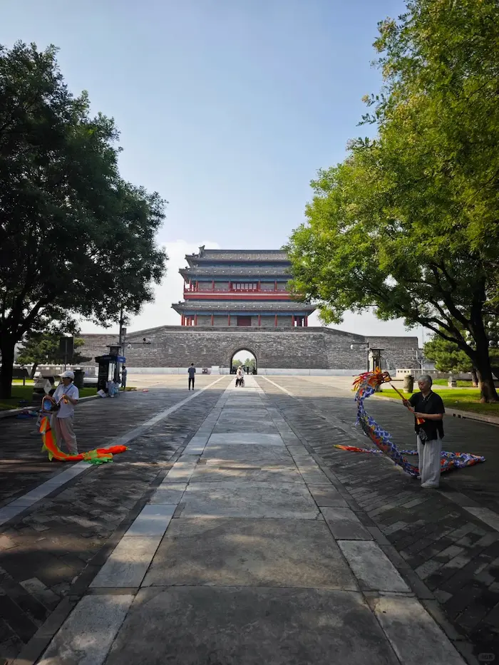
The southern section of the road ruins is defined as the central imperial processional route stretching from Zhengyangmen (Qianmen) to Yongdingmen, with a total length of approximately 3,000 meters.
This imperial processional route served as the exclusive ceremonial avenue used by Ming and Qing emperors to travel to the Temple of Heaven for sacrificial rites and to the Temple of Agriculture for the ritual plowing ceremony.
Today, there are primarily three archaeological sites you can actually see:
| Archaeological Site | Location | Key Highlights |
| ①Stone-Paved Road North of Yongding Gate | Approximately 100 meters north of the Yongding Gate tower | A section of the imperial road from the mid-to-late Qing Dynasty, paved with granite ashlars |
| ②Remains of the Central Axis Road Inside Yongdingmen (Highlight!) | Approximately 400 meters north of Yongdingmen Gate | A cross-section of seven superimposed road layers—six centuries of road history, from the Ming Dynasty to the modern era |
| ③Zhushikou Drainage Channel Site | 5 meters south of the Zhushikou Church | A brick-lined culvert built during the Qing Dynasty, contemporaneous with the Imperial Road |
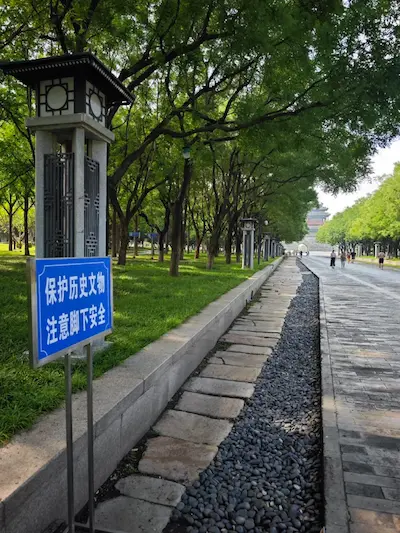
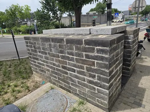
These three sites are not contiguous, fully preserved archaeological sites, but rather distinct points within the southern section’s road heritage system. The distance from①to②is approximately 300 meters, and from②to③is approximately 1,000 meters.
Where to Start? How to Get There?
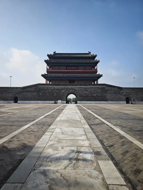
Yongdingmen is the starting point of the entire route and the most easily recognizable landmark.
Walking Directions:
Exit at Yongdingmenwai Station on Subway Line 8 → Walk north for about 10 minutes to reach the Yongdingmen Gate Tower (make sure you’re at the correct location) → Enter Yongdingmen Park from the north side of the gate → Proceed along the Central Axis → Pass by the three historical sites in sequence.
If this is your first visit, we recommend using a map app to navigate to “Yongdingmen Park” rather than searching directly for “Remnants of the Southern Section of Beijing’s Central Axis.”
Recommended Itineraries
⏱30-Minute Express Route (Choose this if you’re short on time)
Yongdingmen Gate Tower (check location)→Walk 100 meters north to①the stone-paved path on the north side of Yongdingmen (10 minutes)→Continue north for 300 meters to②the remains of the central axis road inside Yongdingmen (15 minutes)→Return the same way
⏱45–60-Minute Complete Itinerary (Recommended)
Yongdingmen Gate Tower (check location)→Walk 100 meters north to①the stone-paved path north of Yongdingmen Gate (10 minutes)→Continue north 300 meters to②the remains of the central axis road inside Yongdingmen Gate (20 minutes)→Continue north approximately 1,000 meters to③the site of the Zhushikou drainage ditch (15 minutes)→End
What to See at Each Stop Along the Way
Stop 1: Remains of the Stone Paved Path North of Yongdingmen (approx. 10 minutes)
Location: Approximately 100 meters north of the Yongdingmen City Gate Tower, within the green space along the central axis at the southern end of Yongdingmen Park
A section of the imperial road from the mid-to-late Qing Dynasty has been preserved here. You can see two separate sections of granite stone paving—one to the east and one to the west—with the original stones measuring 1.2 to 1.5 meters in length and 20 centimeters in thickness.
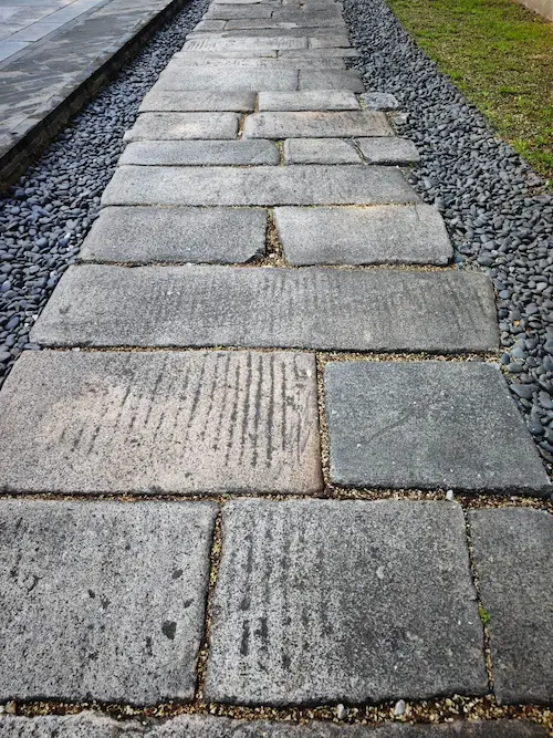
Although the stone slabs in the center of the path are no longer intact, the boundary stones marking the edges of the imperial road remain, providing a clear view of the Qing Dynasty’s stone paving techniques and dimensional standards.
Stop 2: Remains of the Central Axis Road Inside Yongdingmen (approx. 20 minutes)
Location: Approximately 400 meters north of Yongdingmen, in the core area of the central axis of Yongdingmen Park
This is the most significant site among the road remains in the southern section.
From August to September 2022, archaeologists excavated test trenches here, uncovering a complete seven-layer superimposed road section. These seven layers of road are like an open “ledger of time”:
| Layer | Period | Material | Description |
| Layers 1–4 | Modern and Contemporary | Asphalt, cement | Paved during modern urban redevelopment |
| Layer 5 | Republic of China era (after 1920) | Gravel subgrade, tram tracks | A testament to modern transportation changes in the Tianqiao area |
| Layer 6 | Seventh year of the Yongzheng reign of the Qing Dynasty (1729) | Three-part stone slab pavement | Emperor Yongzheng issued an edict to replace dirt roads with stone pavements |
| Layer 7 | Ming Dynasty, Jiajing era | Rammed earth road made of mixed soil | Excavated fragments of Ming Dynasty blue-and-white porcelain |
The bottom layer consists of an early earthen road dating from the Jiajing era of the Ming Dynasty, following the completion of the outer city wall, while the top layer is today’s asphalt road. These road remains span multiple periods from the Ming Dynasty through the modern and contemporary eras, with the earliest layer traceable to the Ming Dynasty.
What Can You See on Site?
- 7-layer superimposed cross-section: Standing at the edge of the excavation pit, you can clearly see the layers of the road from the Ming Dynasty to the present day
- Qing Dynasty imperial road stone slabs: Bluestone slabs in the center, flanked by rammed-earth carriageways on both sides; the stone slabs bear dense ruts from iron-wheeled carts
- Ming Dynasty earthen road: Constructed of rammed mixed earth; fragments of Ming Dynasty blue-and-white porcelain have been unearthed

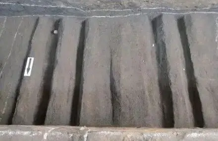
Photography tip: Take an aerial shot from outside the site’s protected area to capture the complete seven-layer cross-section. Distinct cart ruts are visible on the stone slabs.
Stop 3: Ruins of the South Central Axis Drainage Channel at Zhushikou (approx. 15 minutes)
Location: 5 meters south of the Zhushikou Church, beneath the southern section of Qianmen Street
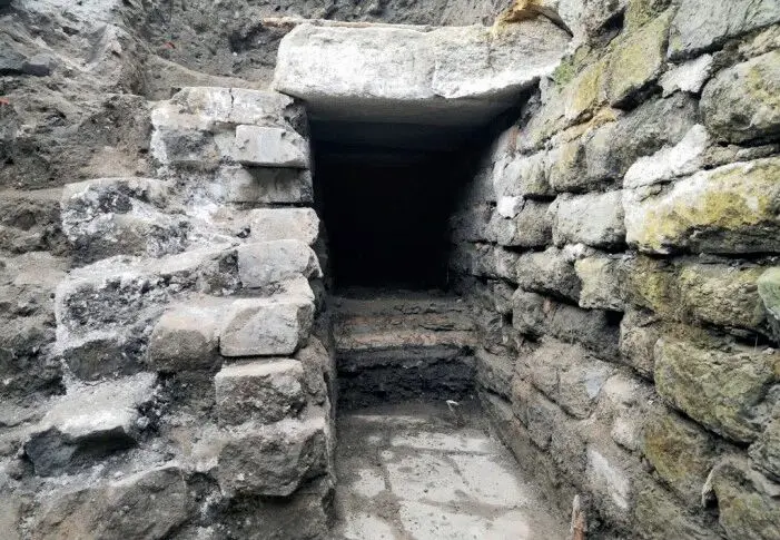
This is a brick-lined underground drainage channel constructed during the Yongzheng era of the Qing Dynasty, at the same time as the Imperial Road. The channel is 0.8 meters wide and 1 meter deep, running symmetrically along the road from east to west. The channel walls still retain the structures of drainage outlets and sedimentation troughs.
Why Is This Road Important?
During the Ming and Qing dynasties, the southern section of the Central Axis was governed by a strict ritual order. The imperial road had a clear width of 4.8 meters (one zhang and five chi in the Qing dynasty) and was paved lengthwise with three long strips of granite; it was reserved exclusively for imperial sacrificial processions, and commoners’ carriages and horses were prohibited from using it.
The side roads on either side were compacted earth paths for carriages and horses, used by commoners, merchants, and transport vehicles.
During the Ming and Qing dynasties, the emperor traveled south along this central axis to the Temple of Heaven to perform rituals honoring Heaven.
Before the seventh year of Emperor Yongzheng’s reign in the Qing Dynasty, this road was still unpaved, becoming muddy and impassable whenever it rained.
Emperor Yongzheng issued a special edict: “The stretch of road from Tianqiao outside Zhengyang Gate to Yongding Gate is extremely low-lying. This is a major thoroughfare for people and horses… whenever heavy rain falls, it becomes impossible to travel.”
Consequently, an order was issued to pave the dirt road with stone. This imperial edict transformed the road from “mud” to “stone.”
Tianqiao is a key junction along this route. Spanning Longxu Gully, it was named “Tianqiao,” meaning “the bridge traversed by the Son of Heaven”; the emperor had to cross this bridge whenever he performed the Heaven Worship Ceremony or conducted the ritual plowing.
Photography Guide
| Shooting Angle | Location | Best Time to Shoot | Tips |
| 7-Layer Road Cross-Section | Stop 2 Core Ruins Area | Morning or Afternoon | Take an aerial shot from outside the protected area of the ruins to clearly see the road layers dating from the Ming Dynasty to the present |
| Close-up of Wheel Ruts | Stop 2 Qing Dynasty Imperial Road Stone Slabs | Afternoon | The shadows of the wheel ruts are most distinct when the sunlight is at an angle |
| Extension of the Imperial Road Stone Slabs | Stop 1 Stone-Paved Path | Early Morning or Evening | Shoot from a low angle to capture the stone slabs extending into the distance, with the Yongdingmen Gate Tower as the backdrop |
| Yongdingmen Gate and the Imperial Road in the Same Frame | Central Axis of Yongdingmen Park | Around Sunset | Stand on the Imperial Road ruins and shoot southward to frame both the Yongdingmen Gate Tower and the stone-paved path beneath your feet |
Nearby Attractions: Half-Day Tour of the Southern Section of the Central Axis
| Attraction | Direction | Walking Time | Highlights | Admission |
| Yongdingmen Gate Tower | South | 2 minutes | Southern starting point of Beijing’s Central Axis | Free |
| Temple of Heaven | Northeast | About a 15-minute walk | Site where Ming and Qing emperors performed sacrifices to Heaven; UNESCO World Heritage Site | Please refer to the Temple of Heaven’s official information for admission prices and reservation requirements |
| Xiannongtan (Beijing Museum of Ancient Architecture) | Northwest | About a 15-minute walk | Site where Ming and Qing emperors performed sacrifices to the God of Agriculture | 15 yuan |
Recommended Half-Day Itinerary (approx. 3–4 hours):
Exit at Yongdingmenwai Station on Subway Line 8→Yongdingmen City Gate (15 minutes; confirm location)→Remnants of the Southern Section of the Road (30–60 minutes; walk north along the Central Axis to view the three sites in sequence)→Return to Yongdingmen→Proceed to the Temple of Heaven or Xiannongtan (2–3 hours)
FAQ
The remnants of the southern section of Beijing’s Central Axis are the most “understated” heritage site along the entire axis.
It is not a palace, nor an altar or temple, nor a city gate. It is simply a road—one that was buried underground and later unearthed by archaeologists.
Yet it is precisely this road that connects the Temple of Heaven, the Temple of Agriculture, Zhengyang Gate, and Yongding Gate; it is this road that allowed the emperor’s imperial procession to travel south from the Forbidden City to offer sacrifices to Heaven at the Temple of Heaven and to perform the ritual plowing at the Temple of Agriculture.
Without this road, the Central Axis would be nothing more than a line drawn on a map.
Today, you can set out from Yongdingmen and walk north along the Central Axis, seeing Ming-dynasty rammed earth, Qing-dynasty imperial stone slabs, Republican-era tram tracks, and modern asphalt roads—six hundred years, seven layers of road, each layer a footprint left by a dynasty upon the earth.
When you visit Beijing, don’t limit yourself to the Forbidden City and the Temple of Heaven. Take a few extra steps in Yongdingmen Park to find that section of stone-paved road protected by a railing.
There, you’ll find a “time cake” of seven overlapping layers, with wheel ruts from hundreds of years ago—a path once walked by emperors and now walked by you.